
Introduction
The settlement of Crustumerium is situated on the Marcigliana Vecchia hill in the volcanic district of the Monti Sabatini. The area is characterised by rolling hills and serrated edges, which rise about 30 to 100 m above the Tiber plain and are divided by many small streams. These streams have severely eroded the volcanic soil, which has resulted in an irregular, hilly landscape.
The plateau of Crustumerium, for example, is surrounded by steep cliffs that have an inclination of about 30 to 40 degrees, creating an easily defensible position, except for its southeastern side. The soil of the entire settlement area consists of a volcanic bedrock type named Tufo di Sacrofano. The soft bedrock permitted the landscape to be easily modified artificially in antiquity, for example for irrigation works, deepened roads, quarries, and the digging of tombs and caves – traces of which are still visible today. Unfortunately, the soft soils have also been subject to massive erosion due to intensive agricultural exploitation in the past; a fact that threatens or has already destroyed part of the archaeological record.
Crustumerium’s Development
Most of our information about the settlement comes from archaeological field surveys, or fieldwalking, which entails systematically mapping artifacts or other archaeological indicators on the surface. At Crustumerium, we are in the lucky situation that the settlement has been mapped on three different occasions. First by Lorenzo Quilici and Stefania Quilici during the 1970s, then by the Sapienza University of Rome in 1995-1996, and finally by the Groningen Institute of Archaeology in 2011.
The oldest phase of habitation is distinguishable by Iron Age pottery of dark impasto, with elaborate incised geometric decorations, covering the time span between 850 and 725 BC. These dates are in correspondence with the earliest tombs from the burial grounds. Whether these traces point to different villages or to a unified settlement is still a matter of debate. What is clear, however, is that the border of the settlement was formalised from the outset.
In the beginning the number of dwellings (huts built from perishable materials) would have been few. Some families with their own agricultural plots would have lived and worked within the settlement limits, occupying a large part of it. Although such huts leave few traces, we can reconstruct them based on tuff (grave) markers modelled after them.
That the settlement flourished during the seventh and sixth century can easily be deduced from the abundant surface material and the growing number of tombs in the burial grounds. The early ‘village’ developed more and more urban characteristics, the overall density of habitation grew considerably within the settlement limits and the surrounding terrain would have been increasingly exploited to support the growing population. Landscape modifications for irrigation and infrastructure offer proof of this. The most striking example is the artificial road trench that was cut straight through the settlement. There is also evidence for a defensive moat and walls, where the terrain offered no natural defence.
Crustumerium seems to have flourished until its life was abruptly cut short around 500 BC. While there is plenty of material dating before 500 BC, later material is virtually absent. The former settlement was incorporated in Rome’s territory and the former settlement was transformed into agricultural land.
Below is a short list of characteristics of the site that are discussed in the text:
- 60 hectares in size
- First settlement in the 9th century BC
- Evidence for large infrastructural projects
- Prominent place in Iron Age road network
- Evidence for public and monumental buildings
- Protected by both natural and artificial defences
- Occupation ends around 500 BC
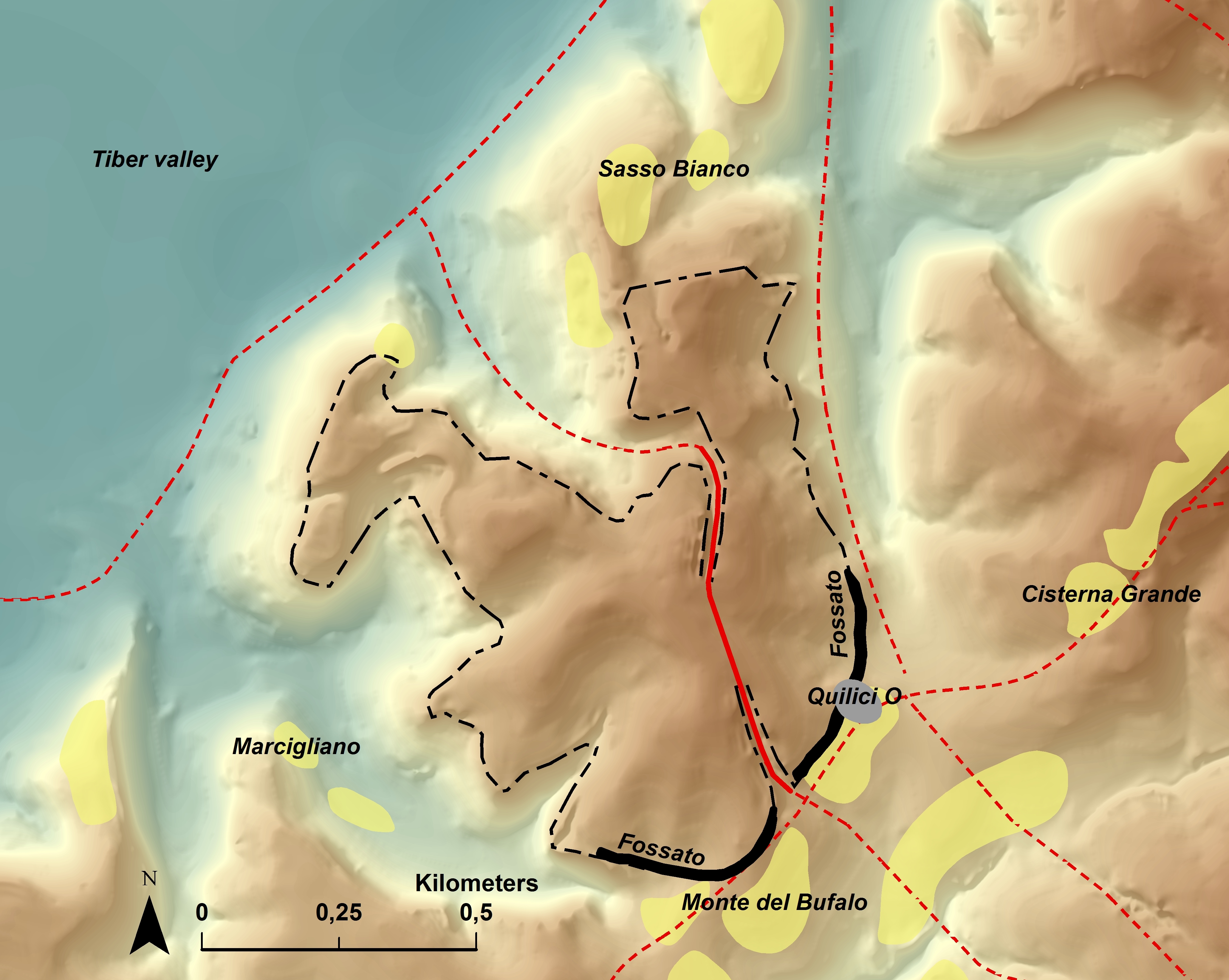
▲ General map of Crustumerium, with the settlement area outlined in black, the (reconstructed) roads in red, and the burial grounds in yellow.
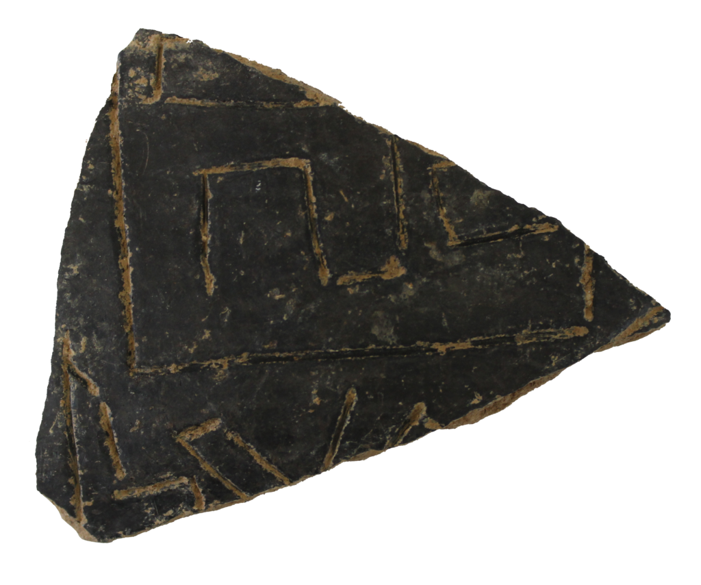
▲ Fragments such as the one above are found both in excavations and during fieldwalking; they are very typical for the earliest phase of Crustumerium.
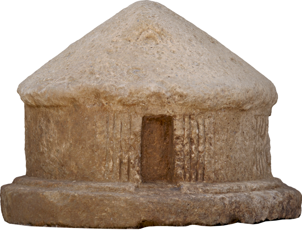
▲ Since huts were built with perishable materials, they leave very few archaeological traces. Grave markers, such as the one above, can help reveal what they may have looked like.
Examples of Monumental Architecture
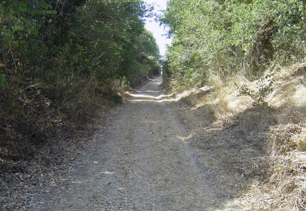
▲ The Road Trench nowadays, still maintaining its function as a road leading up to the settlement plateau. Its steep sides are now covered in vegetation.

▲ Aerial photographs can sometimes reveal features that are impossible to see on the ground, if the conditions are right. This photo from July 2015 shows the fossato as a dark green line, contrasting strongly with the surrounding yellowish vegetation. The filled-in ditch retains water, enhancing plant growth.
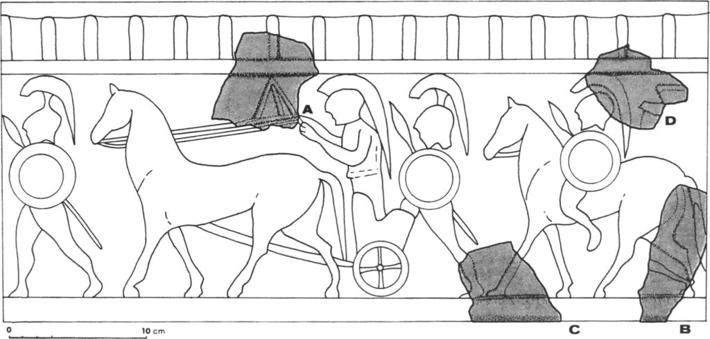
▲ A reconstruction of a terracotta plaque based on fragments found at Crustumerium, showing a military scene. The reconstruction is based on a nearly identical type that occurs at Veii.
Road Trench
Road-cuttings were a common sight in Central Italy during the seventh and sixth centuries BC. They were mostly constructed for pragmatic reasons, i.e. to facilitate vehicular traffic, but also impressed any visitor through their monumentality.
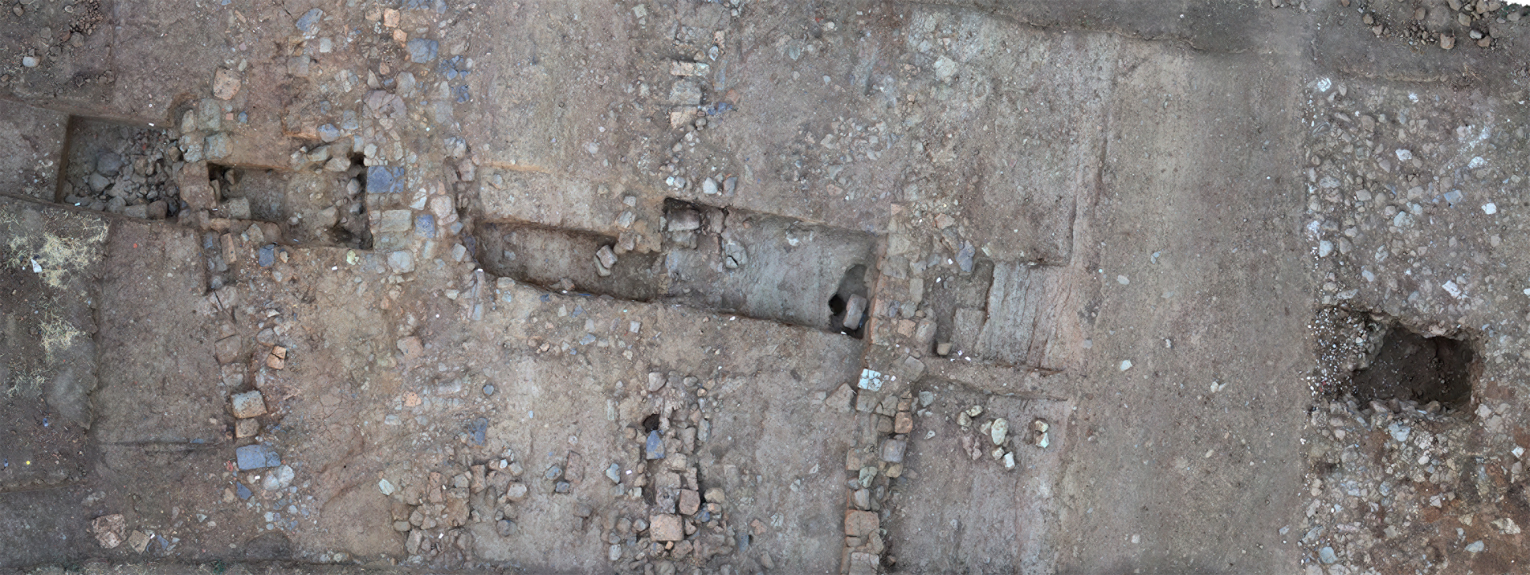
At Crustumerium, road-cuttings are known both inside the settlement and directly outside it; together they must have made up an impressive infrastructural network. Most of these cuttings have filled up naturally over time, but their presence has been demonstrated through geophysical research and targeted excavations.
A major road-cutting can still be seen today, running across the settlement from the southeast to the northwest (see map on this page). Originally, it had a depth of ca. 7 m and a max. width of 30 m, indicating that its construction must have taken great efforts. Calculations suggest that it took a workforce of 100 m close to one year to complete this cutting alone.
The Fossato
Steep cliffs provided ample natural protection on nearly all sides of the settlement, except for its southern perimeter where the slope is much more gentle. A massive defensive moat (or in Italian, a fossato) was dug along the southern part of the settlement, where the landscape offers no natural defence. Its full course could be mapped using aerial photography, geophysical prospection, and manual augering, indicating a depth of ca. 9 m and a depth of up to 4.5 m.
The precise date of this moat is still unknown, but we can speculate that the necessity for defence against external threats places this feature early in the settlement’s history. An early date sits well with similar defensive works found elsewhere in Central Italy.
The Evidence for Monumental Buildings
So far, no monumental buildings belonging to the settlement have been located at Crustumerium. Large-scale erosion has probably destroyed any remains, leaving only the deep features discussed above and the graves discussed elsewhere. From surface finds and the occasional find during excavations there is, however, evidence that monumental buildings did exist during the late seventh and sixth centuries BC. Architectural terracottas, which will have adorned such buildings, have been found on the settlement plateau and just outside it. These resemble specimens occurring at nearby Etruscan and Latin sites, such as Veii and Rome.